Read this episode on the "22. Silver Ring" page.
First, let's explore its location.
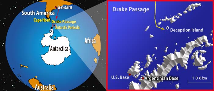
After departing Buenos Aires, the capital of Argentina, Aomi sailed south across the South Atlantic Ocean for about a month. Her first destination was Deception Island, located off the coast of the Antarctic Peninsula, which extends toward South America.
After navigating the stormy Southern Ocean and the Drake Passage, I finally spotted land. However, unlike typical ports or coastlines, there was no safe place to rest.
Now, let's examine the environmental conditions of Deception Island.
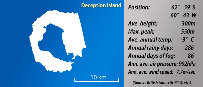
Deception Island is rugged, with an average elevation of 300 meters, and surrounded by sheer cliffs, making it seem nearly impossible to find a suitable landing spot.
The average annual temperature is -3°C. For comparison, Reykjavík, Iceland, has an annual mean temperature of 5.1°C, and Oslo, Norway, has 7.0°C, making Deception Island considerably colder. Unsurprisingly, no one lives there.
With 286 days of precipitation per year, it rains or snows 87% of the time, highlighting the harsh weather conditions on Deception Island. The precipitation is nearly as severe as in the Patagonian archipelago (click to see the chart).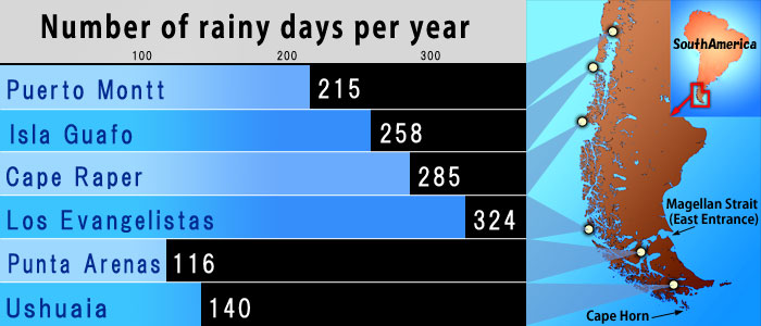
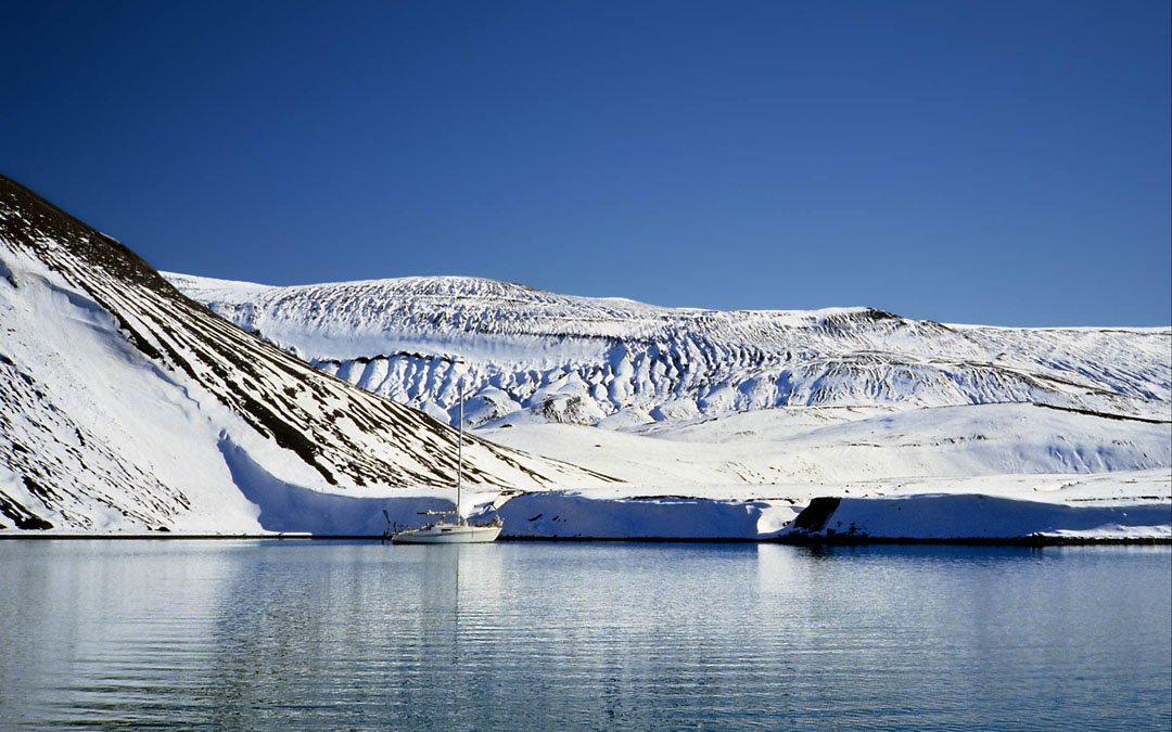
Clear weather, like in the photo at the top of the page, is a rare occurrence.
The figure above also shows an average wind speed of 7.7 meters per second, which corresponds to wind force 4 and is close to wind force 5. According to wind force classifications, wind force 4 means 'sand and dust are blown up, paper fragments are blown around, and small branches move'—definitely not a mild wind.
It's important to note that this measurement is taken at an altitude of 8 meters within the island's ring, where the surrounding mountains provide some shelter from the strong winds. Even so, the fact that the wind blows this hard inside suggests that conditions outside are even more severe—making it hard to imagine how a small sailboat like Aomi could endure them.
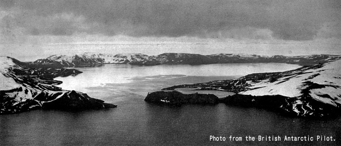
This aerial photograph of Deception Island captures its cold, harsh landscape, yet it possesses an undeniable charm.
A break in the island's front, known as 'Neptune's Bellows,' is where Aomi will enter. Will she pass through safely? What awaits inside?
*
Here is a quote from the US Sailing Directions:
DIRECTIONS—Charcot suggested the following directions for passing through Neptunes Bellows into the harbor: "round the island at sufficient distance until the pass is made out.
The photo below was taken while Aomi was sailing around the island, searching for the entrance and carefully avoiding rocks not marked on the chart.
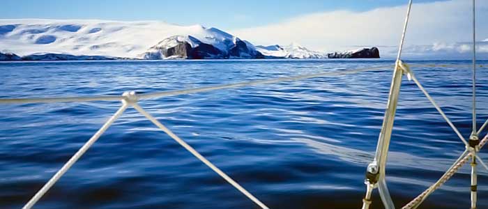
I worried whether an entrance actually existed. It seemed like an immense mass of rock and snow, and I feared the break would never appear.
Fortunately, the snowy mountains dazzled under the clear skies, and the sea shone a deep blue. Sailing through such a landscape felt like a dream. I was glad to have come, but I knew this was only the beginning.
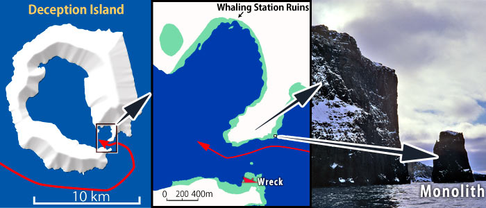
The following maps and a photo show the area near the entrance. The map in the center provides a closer view of the area shown in the map on the left, with land in white, the sea in blue, and shallow areas in light green.
As shown, a shallow spot lies in the middle of the entrance. This underwater hazard, 'Ravn Rock,' is invisible, and its exact location is uncertain. Additionally, the red mark at the bottom of the figure indicates a shipwreck in the shallows.
Will Aomi safely navigate the entrance?
Let's continue with the US Sailing Directions:
Steer so as to pass close to the monolith at the entrance, between 50 and 100 yards, then follow the northeast cliff (typo? "northwest cliff") for about 100 yards, taking note of the fact that this cliff, having a perpendicular fall of 400 feet, would have a tendency to make one believe they were too near.
You must sail close to the northern cliff to avoid running aground on the shoals in the middle of the entrance. However, getting too close risks hitting uncharted rocks near the cliff.
They also warn against misjudging the distance, so Aomi navigates carefully along the cliff after passing the monolith.
It was just as they described. I had no idea how close I was to the sheer cliff face. It looked like I was passing so close to the rocks that I might hit them at any moment. However, the depth sounder indicated I still needed to get even closer.
I could have estimated the distance if a building or person had been nearby for reference. But with only the rock wall, I had nothing to compare against. I could see the patterns on the rocks clearly, but judging the distance was impossible.
Fortunately, Aomi passed through the entrance without incident, and a flat expanse of water, like a quiet blue pond, opened up.
The hull was completely still—as if time had stopped, like I had wandered into another world.
*
As soon as I entered Deception Island, I came upon a mysterious scene.
The light blue dot on the lower right of the map below shows Aomi's location. Both the peninsula marked A and the distant ridge marked B are visible together.
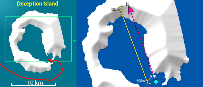
Peninsula A and Mountains B are approximately 500 meters and 10 kilometers away, respectively, and should be easy to distinguish.
However, when I strained my eyes to locate the peninsula to confirm Aomi's position, it was nowhere to be seen. I saw only blue water and white mountains ahead, but the peninsula that should have been visible in front of the mountains had disappeared.
Strangely enough, only the lower parts of the distant white mountains seemed to be moving rapidly. This was probably because the visible position of the peninsula changed as Aomi advanced. The mountains, 10 kilometers away, and the peninsula, 500 meters away, appeared equally clear, with no sense of distance.
In daily life, we take for granted that nearby objects appear close and distant ones seem far away. But in the Antarctic, this common sense doesn't necessarily apply. In a world where perspective is lost, how can we navigate safely? How can we avoid collisions while determining the positions of rocks and icebergs?
Here is a description from a British Navy Antarctic pilot:
There is almost no dust or solid particles in the Antarctic air and the prevailing winds blowing off the continent have small moisture content. As a consequence the visibility is usually very good, and often exceptional, a fact which, if not appreciated, may lead the observer into serious error when judging distances. An object which may be thought to be but 5 miles distant could well be 30 miles away, and mountains have been sighted at 300 miles.
When you can't distinguish between near and distant objects, you can quickly lose your sense of location.
This was the moment I truly realized just how challenging sailing in the Antarctic could be.
*
As Aomi ventured deeper into the island's ring, I immediately saw the remnants of an old whaling station to the right.
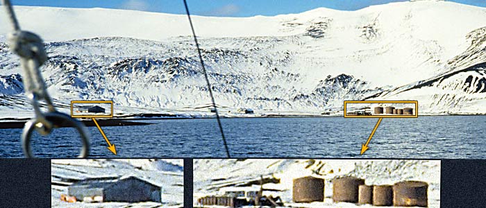
I considered anchoring in this bay, known as Whalers Bay, for the night, but decided against it. The bay was too vast for a small boat like Aomi, and many old anchors from whaling ships were said to be scattered on the seafloor. (To learn more about this whaling station, visit the Whaling Base in Deception Isle page.)
*
Aomi went further into the island, searching for the cove I had chosen earlier.
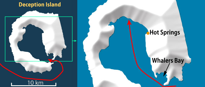
Along the way, I passed an area where steam rose from the water—hot springs gushing and mixing with the seawater.
This spot is popular with Antarctic cruise ships, offering a unique experience: "bathing in the Antarctic!" In the web-sourced photo below, visitors are enjoying a sand bath. According to a book I read, you can swim nearby, though the water quickly turns cold as you move away from the shore.
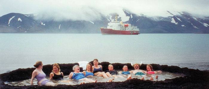
( Picture published by the author Lyubomir Ivanov CC BY-SA 3.0)
The background of this page is a photo of Antarctic snow.
All rights reserved.