In narrow straits or channels between mountains, wind direction is crucial. A slight shift in high-altitude winds can dangerously alter apparent winds in the channels, putting a small vessel at risk. Study geographical features on charts or maps and estimate wind direction and force beforehand.
Japanese sailing magazine KAZI
This is an episode of Aomi in the Strait of Magellan.
Do you know:
What is the southernmost point of Africa?
- Cape Agulhas
- Cape of Good Hope
- Cape D. Lawley
What is the southernmost point of Australia?
- Adelaide
- Tasmania
- Bishop and Clerk Islets
What is the southernmost point of South America?
- Cape Horn
- Diego Ramirez Islands
- Mar del Plata Island
What was the result? We don't know much about geography, do we? One thing we often confuse is Cape Froward, the southernmost point of the South American continent.
Aren't the Diego Ramirez Islands the southernmost point, as mentioned above? No, I mean the southernmost point of the CONTINENT! South of Cape Froward is just a group of islands.
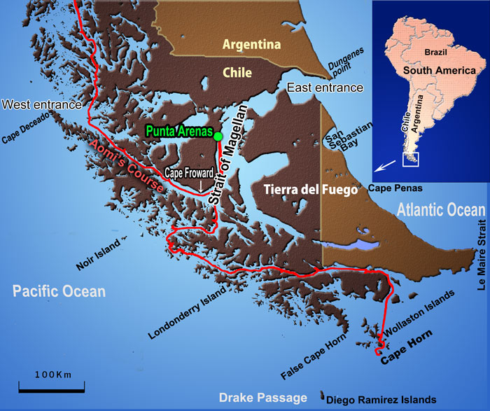
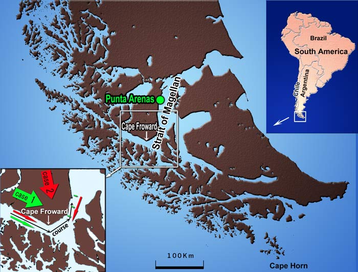
Sailing through the Chilean Islands, Aomi reached the Strait of Magellan. After rounding Cape Froward, Aomi was headed for Punta Arenas, a city with a population of about 120,000. I hadn't had a chance to get food for more than two months because most of the islands in the Patagonian Archipelago were uninhabited. That was the main reason for visiting Punta Arenas.
Until the Panama Canal opened in the 20th century, the strait was a passage from the Atlantic to the Pacific. It is shorter than rounding Cape Horn and protected from the high waves of the open sea. Punta Arenas, located midway along the strait, flourished as a coal supply base in those days.
By the way, what is it like sailing between numerous islands in a small sailboat? The remarkable features of the strait are the breathtaking scenery and violent winds.
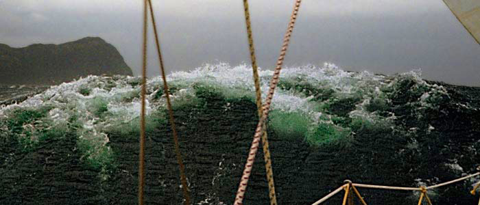
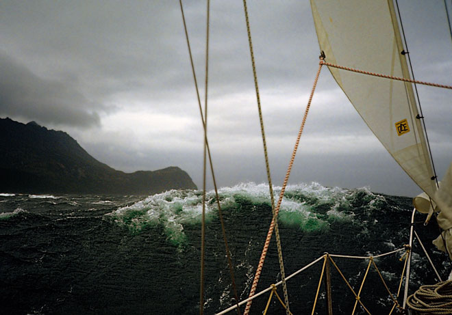
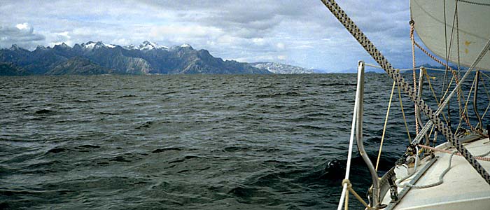
Look at the photo above. The land on the left is Cape Froward, the southernmost point of the South American continent. You can see the top of the wave breaking and dancing. There are faint parallel lines of ripples caused by severe wind on the blackish slope of the wave. Furthermore, as you see in the photo, the breaking wave looks green—an impressive transparent green!
The hoisted sail was only a tiny storm jib of 2.4 square meters, smaller than a single bedsheet. Even with such a small sail, Aomi sailed through the Strait of Magellan at a surprising speed. I pulled down the sail out of fear, but Aomi was still moving fast. The severe wind, blowing against the mast and hull, was pushing Aomi powerfully to leeward.
Why is the wind so strong in the Strait of Magellan? Imagine a shallow box filled with water and stones, like the one below.
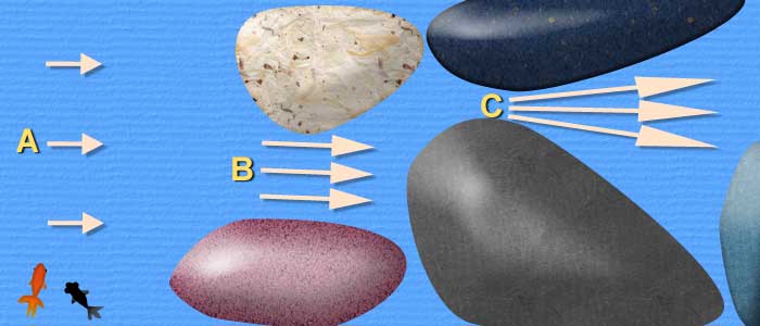
When water flows from the left, the velocity at point B is higher than at point A because it is narrower at B. At point C, the speed of water is much higher than at B because the gap is much smaller. The speed of the flow depends on the width (cross-section) of the passage because the flow rate (e.g., liters per second) is constant.
Please notice that the velocity would be much lower without the stones. The speed at B and C will be the same as at A if there are no stones. Stones work as accelerators of the flow.
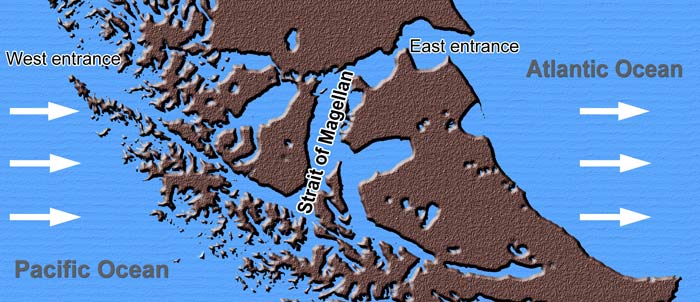
When the prevailing wind blows from the west, the islands in the image above act as accelerators, as described, especially where the strait is narrow. That is one of the reasons why the wind is so strong there. It can be stronger than the wind on the open sea. Sailing in such conditions is a hard trial for yachtsmen.
The photo below shows Habana Point in the Strait of Magellan. Washed and polished by the waves and swell from the Pacific Ocean, the rocks look like eerie white skeletons. How harsh was the wilderness that shaped this scenery? At a glance, I realized what kind of place the Strait of Magellan was. I will never forget the strong impact it had on me.
(Mouse over to show the map. )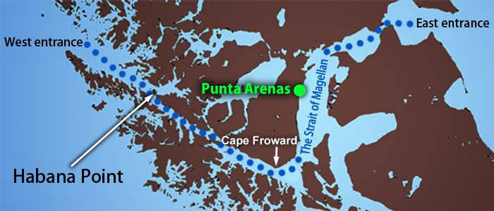
Though the climate in the strait is so fierce, there are better days as well. On both sides of the strait, mountains continue; distant mountains are blue silhouettes, and high mountains have pale-white glaciers. Sometimes, the sunlight spots the rugged slope of the mountain, and the rocks shine gold. In the next moment, clouds hide the sun, and the rocks become brownish violet at once. That was a mysterious scenery. Sailing in such a place in a sailboat must be a fantastic experience.
While sailing in the Strait of Magellan, I saw only two cargo ships. Though the importance of the strait is less today, some vessels too big to go through the Panama Canal still sail in the strait.
When sailing in the Strait of Magellan in a small sailboat, you had better navigate only in the daytime, even if you are more than two. You sail during the day and have to anchor in a bay at night.
(Mouse over to show the map.)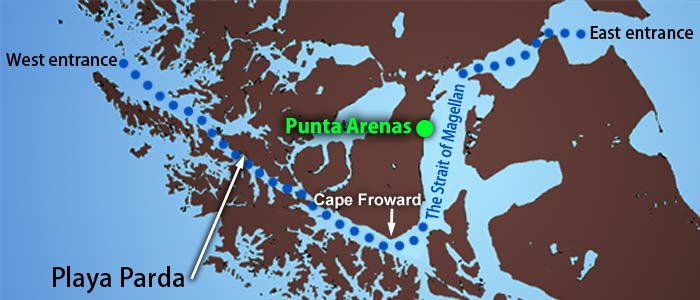
One day, Aomi stayed in a small bay called Playa Parda. Snow-covered mountains are in the back, and eerie violet-brown mountains are in the front (see the photo above). The lines that look like white threads are waterfalls. Plants are scarce on the rocks. The smooth surface of the rock, which looks polished, tells of the severe climate there. As soon as I entered the bay, I thought, "What an unearthly scenery this is!"
After dropping an anchor, I rowed a small dinghy to tie a mooring rope to the shore. You can't rely on just anchors in a region where strong winds prevail.
I looked for something to tie the rope to, but nothing was suitable. All I found were weeds and low, thin trees. Without something to secure the line to, the wind could blow Aomi away at night.
Then I recalled a technique I had read about. It was about setting the flukes of an anchor in the crack of a rock. I rowed back to Aomi, got an anchor, and rowed toward the coast again.
Unexpectedly, the angle between the fluke and the shank was too small for the crack. The fluke came out of the crack when I pulled the rope.
I decided to put the whole anchor in the crack, but every crack around was too narrow for the anchor. In the end, I disassembled the anchor, removed the flukes, and made a cross, as shown below. (Genuine Danforth anchors cannot be disassembled in this way.) I named it the "Rock Anchor."
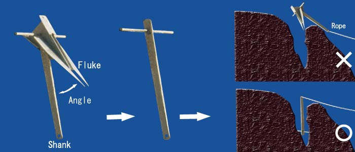
By putting the cross in the crack, I was able to secure the rope firmly to the coast. There was no more danger of being blown away by the strong wind.
The growls of the wind woke me up several times during the night, but I felt at ease because of the rope securing Aomi to the coast.
Back to main page.
All rights reserved.